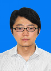
曹金山,男,博士,副教授,硕士生导师,中国人工智能学会会员,主要从事光学卫星图像/视频数据高精度几何处理的理论、方法与应用研究。主持战略支援部队预研项目1项、国家自然科学基金青年项目1项、国防973计划专题1项、中国博士后科学基金面上项目1项以及横向项目多项。获测绘科学技术奖一等奖1项、电力建设科学技术进步奖二等奖1项,以第一和通讯作者发表SCI论文10余篇,合著专著1部,获国家授权发明专利7项。研制光学卫星在轨几何定标软件1套、光学卫星空中目标实时定位软件1套。
联系方式:
邮箱:caojs@hbut.edu.cn
Q Q:85630869
研究方向:
光学卫星图像/视频数据几何处理、运动目标检测与轨迹融合、图像超分辨率重建等。
主持项目:
1.战略支援部队预研项目:**技术,2023
2.国家自然科学基金青年项目:高分辨率光学视频卫星帧间几何关系子像素级精确建模与反演方法,2019
3.中央高校基本科研资金项目:基于条带约束的多景单视卫星影像联合定位,2017
4.中央高校基本科研资金项目:综合控制点、线的高分辨率卫星影像精确目标定位,2016
5.国防973计划项目专题:**在线标定修正方法研究,2015
6.中国博士后科学基金面上项目:基于多源控制的高分辨率卫星传感器在轨几何定标,2014
7.横向项目:光学对天定标分析试验研究,2023
8.横向项目:红外相机定位误差实时修正技术,2023
9.横向项目:目标轨迹实时精化技术,2023
10.横向项目:目标三维图像重建算法软件研制,2023
11.横向项目:地面定标与目指信息生成软件研制,2023
12.横向项目:目标多星轨迹融合软件改造,2022
13.横向项目:目标多星观测轨迹融合与三维定位方法研究,2021
14.横向项目:高分辨率视频卫星传感器校正算法研究,2020
15.横向项目:定标与检验场数据及软件研制,2020
获奖情况:
1.曹金山(13/15),互联网智能遥感卫星与在轨处理关键技术及应用,测绘科学技术奖一等奖,2023
2.曹金山(2/10),复杂环境能源工程空间数据高精度快速处理关键技术研究与应用,电力建设科学技术进步奖二等奖,2023
代表性论文:
1.Jinshan Cao, 2023. Geometric Calibration of the Whiskbroom DaQi-1 WSI Based on an Equivalent Linear-array CCD. IEEE Transactions on Geoscience and Remote Sensing, 61, 5616713.(SCI,一区)
2.Jinshan Cao, Wenshu Bao*, Haixing Shang, Ming Yuan, Qian Cheng, 2023. GCL-YOLO: A GhostConv-based Lightweight YOLO Network for UAV Small Object Detection. Remote Sensing, 15, 4932.(SCI, 二区)
3.Jinshan Cao*, Haixing Shang, Nan Zhou, Shu Xu, 2022. In-orbit Geometric Calibration of Multi-Linear Array Optical Remote Sensing Satellites with Tie Constraints. Optics Express, 30(15): 28091-28111.(SCI, 二区)
4.Jinshan Cao, Nan Zhou, Haixing Shang, Zhiwei Ye*, Zhiqi Zhang, 2022. Internal Geometric Quality Improvement of Optical Remote Sensing Satellite Images with Image Reorientation. Remote Sensing, 14(3), 471.(SCI, 二区Top)
5.Zhiqi Zhang, Wen Lu,Jinshan Cao*, and Guangqi Xie, 2022. MKANet: An Efficient Network with Sobel Boundary Loss for Land-Cover Classification of Satellite Remote Sensing Imagery.Remote Sensing, 14, 4514.(SCI, 二区Top)
6.Zhiqi Zhang, Huigang Zheng,Jinshan Cao*, Xiaoxiao Feng, and Guangqi Xie, 2022. FRS-Net: An Efficient Ship Detection Network for Thin-Cloud and Fog-Covered High-Resolution Optical Satellite Imagery. IEEE Journal of Selected Topics in Applied Earth Observations and Remote Sensing, 15, 2326-2340.(SCI)
7.Jinshan Cao, Fengwen Wang, Ying Zhou, Zhiwei Ye*, 2021. In-orbit Geometric Calibration of HaiYang-1C Coastal Zone Imager with Multiple Fields. Optics Express, 29(12): 18950-18965.(SCI, 二区)
8.Jinshan Cao, Zhiqi Zhang*, Shuying Jin, Xueli Chang, 2020. Geometric Stitching of HaiYang-1C Ultra Violet Imager with a Distorted Virtual Camera. Optics Express, 28(9): 14109-14126.(SCI, 二区Top)
9.Jinshan Cao, Zhiqi Zhang*, Shuying Jin, 2020. Sensor Orientation of HaiYang-1C Ultra Violet Imager Based on a Piecewise Rational Function Model. Journal of Applied Remote Sensing, 14(1): 017501.(SCI)
10.Jinshan Cao, Bo Yang*, Mi Wang, 2019. Jitter Compensation of ZiYuan-3 Satellite Imagery Based on Object Point Coincidence. International Journal of Remote Sensing, 40(16): 6116-6133.(SCI)
11.Jinshan Cao, Jianhong Fu*, 2018. Estimation of Rational Polynomial Coefficients Based on Singular Value Decomposition. Journal of Applied Remote Sensing. 12(4): 044003.(SCI)
12.Jinshan Cao, Jianhong Fu*, Xiuxiao Yuan, Jianya Gong, 2017. Nonlinear Bias Compensation of ZiYuan-3 Satellite Imagery with Cubic Splines. ISPRS Journal of Photogrammetry and Remote Sensing, 133: 174-185.(SCI, 一区Top)
13.Jinshan Cao, Xiuxiao Yuan*, Jianhong Fu, Jianya Gong, 2017. Precise Sensor Orientation of High-Resolution Satellite Imagery with the Strip Constraint. IEEE Transactions on Geoscience and Remote Sensing, 55(9): 5313-5323.(SCI, 二区Top)
14.Jinshan Cao, Xiuxiao Yuan*, Jianya Gong, Miaozhong Xu, 2017. Extrapolated Georeferencing of High-Resolution Satellite Imagery Based on the Strip Constraint. Photogrammetric Engineering & Remote Sensing, 83(7): 493-499.(SCI)
15.Jinshan Cao, Xiuxiao Yuan*, Yi Fang, Jianya Gong, 2016. Geometric Calibration of Ziyuan-3 Three-line Cameras Using Ground Control Lines. Photogrammetric Engineering & Remote Sensing, 82(11): 893-902.(SCI)
16.Jinshan Cao, Xiuxiao Yuan, Yi Fang, 2016. Tri-Stereo Model Orientation of High-Resolution Satellite Imagery Combining Ground Control Points and Lines. Photogrammetrie Fernerkundung Geoinformation, (3): 125-140.(SCI)
17.Jinshan Cao, Xiuxiao Yuan, Jianya Gong, 2015. In-orbit Geometric Calibration and Validation of ZY-3 Three-line Cameras Based on CCD-detector Look Angles. The Photogrammetric Record, 30(150): 211-226.(SCI)
学术专著:
1.袁修孝,曹金山, 2012. 高分辨率卫星遥感精确对地目标定位理论与方法. 北京: 科学出版社.
软件研制:
1.光学卫星在轨几何定标软件:已成功应用于我国近40颗光学卫星几何定标处理
2.光学卫星空中目标实时定位软件:已成功应用于我国4颗光学卫星实时定位处理
发明专利:
1.曹金山, 刘熊峰, 叶志伟,2023. 一种带有片间约束的面阵成像卫星在轨几何定标方法.
2.曹金山, 叶志伟, 王志林, 刘熊峰, 杨航, 2022.一种光学卫星多面阵传感器片间无缝几何定标方法.
3.曹金山, 叶志伟, 杨航, 王志林, 刘熊峰,2022.一种光学卫星传感器在轨分时几何定标方法.
4.曹金山, 张致齐, 王密,2021. 一种基于有理函数模型的卫星视频相机在轨几何定标方法.
5.曹金山, 张致齐, 王密,2020.一种带有地理编码的光学卫星视频稳像方法及系统.
6.曹金山, 袁修孝, 龚健雅,2020. 基于控制直线的光学卫星传感器在轨几何定标方法及系统.
7.曹金山, 袁修孝, 龚健雅,2019. 光线同姿约束的零交会光学卫星影像联合平差方法及系统.
软件著作权:
1.曹金山, 张致齐. 光学卫星视频稳像软件, 2020
2.曹金山. 光学卫星影像对地目标定位软件, 2017
3.曹金山. 光学卫星传感器在轨几何定标软件, 2016
 湖北工业大学校园美景